 By Guest contributor: Ivan Robinson
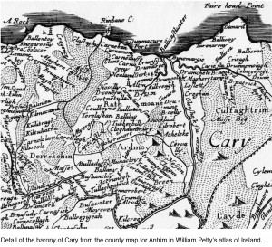
William Petty’s atlas of Ireland is an historic document that deserves to be better understood beyond the shores of the island it depicts. Published under the title Hiberniae Delineatio in1685, it comprised a general map, a map of each of the four provinces, and thirty-two county maps. It was the first printed atlas of Ireland and the first in Europe to be based on measured surveys. The regional maps contained a level of accuracy and detail never previously printed and drawn to scale across a whole country. The general map provided the earliest, widely available outline of Ireland substantially as it is known today. It became the definitive shape of Ireland for the next century.
But the atlas was more than a mirror of the physical and human geography of Ireland; it was also testimony to the role maps themselves can play in the historical process. Its main source was Petty’s Down Survey, which was an instrument of state control designed to transform Irish society through a massive change in land ownership, from Catholic to Protestant hands. The effect of this ‘plantation’was dramatic: in the twenty-year period between 1640 and 1660, Catholic ownership of Irish land dropped from 60 percent to less than 10 percent.
There is a growing acceptance amongst cartographic historians that an understanding of early maps is best achieved by integrating scientific and non-scientific approaches to map history. The scientific approach, which stresses the value-free, objective nature of maps, needs to be balanced with the idea that maps are also the products of other factors, including social, economic and political influences prevailing at the time the maps were made.
From a scientific perspective, the Down Survey and atlas were not noted for cutting-edge methods. Rather, the success of Petty’s cartography was due to his organizing ability and his access to central government control. With the backing of a military government under Oliver Cromwell, he engaged a thousand men on the survey and completed the bulk of the work over a thirteen-month period in 1655-56. The field surveyors used well-tried traversing methods where lengths were measured by chain, and bearings by a surveying instrument called a circumferentor. Petty had these measurements plotted, or “surveyed downe”(hence the name of the survey), onto manuscriptparish maps. The parish maps were subsequently used as the ultimate source of much of the detailed information for the printed maps in the atlas.
The historical context largely determined the non-scientific influences on Petty’s maps. The English government determined that it would repay, with land confiscated from Irish Catholics, the costs incurred by Cromwell’s New Model Army to crush the Irish Rebellion (1641-53). But the government had little knowledge of either how much forfeited land would be available to settle its debts or where, precisely, such lands were located. The overriding purpose of the Down Survey was to provide this urgently needed information. The consequences that flowed from this direction were evident on the atlas maps. Firstly, the focus was on territorial boundaries within each county; physical and cultural features were usually included only where they helped to define those boundaries or to identify unproductive mountain and bog land. Secondly, lands already in Protestant ownership were not mapped in detail, leaving significant information gaps across half the country. Nevertheless, by virtue of the quality and unprecedented extent of mapping in the areas it did cover, the atlas provided a considerably clearer picture of Ireland’s geography than previously found in the seventeenth century.
Petty was aware from the outset that the incomplete coverage of the Down Survey stood in the way of his (ultimately unsuccessful) ambition to map the whole of Ireland. He compensated, in part, by conducting a concurrent boundary survey of baronies, the territorial divisions that fell between counties and parishes, across the entire country. The resulting barony maps, which continued to rely on the parish maps for detailed information within each barony, became the principal source for the atlas maps.
Much is known about the sources Petty used for his atlas but some unanswered questions remain. Almost 40 percent of the place names on the map for the county of Donegal were derived from sources other than the barony maps. Does the pattern in Donegal, an area not well covered by the Down Survey, apply to other regional maps and, if so, what other sources were used? The general map of Ireland also poses questions with respect to sources. Its coastlines did not follow those on the regional maps, as might have been expected. Again we are left to ask: what alternative sources were relied on?
It appears that with deeper understanding comes a heightened awareness that much remains to be learned about Petty’s atlas of Ireland…
______________________________________________________________________
Read the full paper: Ivan Robinson, “Understanding William Petty’s Atlas of Ireland.”Cartographica 49:1, 2014, pp. 35-51. http://bit.ly/carto491robinson
Contact the author: jrobi@shaw.ca
Comments on this entry are closed.